I. 머리말
지난 2019년 4월 우연히 한탄강이 여울이 많은 강이라는 점 하나로 드네프로강을 한탄강이 아닌가 하는 글을 썼다. 이때가 벌써 4년전이다. 그러나 그후 흑해지역 주위에 대한 연구가 더 이루어지고, 견훤의 후백제가 발칸반도의 제1 불가리아제국이라는 글을 쓰면서 이 부근에 대한 한국사의 가능성을 여러 번 확인했다. (아래 자료 참조) 특히 흑해위의 Old Great Bulgaria가 고구려의 마지막 시기인 점을 고려하면, 이 지역 주위의 궁예의 후고구려 가능성은 매우 높다 하겠다. 따라서 이제 보다 본격적인 연구를 거쳐 한탄강의 위치와 태봉의 수도 철원, 흑양을 추정해 보고자 한다. 이글도 지난 3월 시작했는데, 그동안 다른 연구로 밀려 있었는데, 이제 마무리 하고자 한다.
II. 흑해 주위의 역사
필자는 흉노의 고향 약수가 스웨덴에 있다고 추정했다. 그리고 산해경에서 말하는 '북해지우 동해지내'의 위치에 있는 조선이 핀란드지역이 아닌가 한다. 아래 지도에서 그래서 빗살무늬토기 지역인 Comb Ceramic Culture지역이 주목되는 지역이다. 그 아래 Dnieper-Don Culture 지역(흑해 위 지역)도 구막한국 지역이 아닌가 하는 의문을 가지고 있다.

European Middle Neolithic periode (BC 4200 - BC 2200 ) (source : Wikipedia)
https://lainfos.tistory.com/74
스키타이인의 일원인 키메리언은 누구인가? (I)
지난 글 중앙아시아의 Massagetae에 대한 분석에 이어, 같은 스키타인이면서도 중앙아시아가 아닌 흑해주변, 코카서스산맥, 아나톨리아 및 유럽에서 활동한 Cimmerians에 대해서 보다 상세하게 검토
lainfos.tistory.com
흑해 위의 지역은 스키타이의 고향이라 한다. 스키타이의 일원인 키메리언(기원전 7-5세기)도 본 고향은 흑해위 지역이라 한다. (상기 글 참조) 이 지역은 기원전 100년경에도 스키타이의 지역으로 묘사된다 (아래 지도 참조)

Scythia in BC 100 (source : Wikipedia)
필자는 발해 시대의 흑수말갈이 모스크바지역에서 이동한 흑해위의 마자르족을 말하지 않나 추정했다. (아래 글 참조)
https://lainfos.tistory.com/229
흑해위 마자르족은 흑수말갈인가?
I. 흑해 위의 Magyar족 지난 글, 견훤과 시메온 왕과의 비교에서 살펴 보았듯이, 당시 흑해 위에 있던 마자르족은 비잔틴제국과의 연합으로 불가리아를 공격했다. 아래 지도에서 오른쪽 상부에 MAGY
lainfos.tistory.com
또한 흑해 주변의 카자르칸국이 발해의 일부라 추정했다. (아래 글 참조)
https://lainfos.tistory.com/255
흑해 주변의 카자르칸국(650/660-969/1050)은 발해의 일부인가?
발해의 일부라 판단되는 Khazar Kaganate(650/660 - 969/1050)는 여러가지로 발해의 특성과 일치한다. 그러나 그 구체적인 검토는 후일 발해에 관한 연구에서 본격적으로 하고, 여기서는 Pechenegs지역에 이
lainfos.tistory.com
흑해에서 가까운 발칸반도에는 후백제의 견훤이 있었다 추정했다. (아래 글 참조)
https://lostcorea.tistory.com/1653
후백제의 견훤은 불가리아 1제국의 Simeon왕인가?
필자는 비잔틴제국을 백제라 판단했다. 서로마제국도 일부는 백제로 판단했다. 단 비잔틴제국은 백제 멸망 후에는 신라로 판단했다. 통일신라의 세력은 유럽 역사에서 무슬림으로 나타난다. 스
lostcorea.tistory.com
그리고 흑해위에 있던 Old Great Bulgaria (632-668)는 고구려의 말기 시대의 모습이라 추정했다. (아래 글 참조)
https://lostcorea.tistory.com/1645
흑해 위 Old Great Bulgaria(632-668)는 고구려 말기 역사의 일부이다
흑해위 지역에는 AD 632년부터 불가리아가 나타난다. Old Grea Bulgaria, Kara Bulgar, Volga Bulgaria 등이 그것이다. 서양사에서는 Huns, 즉 훈족과 Bulgars, 즉 부여족을 아시아에서 온 부족으로 판단한다. 필자
lostcorea.tistory.com
이러한 연구를 고려할 때, 흑해 주위에 후고구려 궁예의 철원(흑양)과 한탄강이 있을 것으로 추정된다. 따라서 이에 대해서 자료를 보면서 한탄강과 수도 철원(흑양)을 비정해 보고자 한다.
III. 한국사에서 한탄강과 철원에 대한 자료
1) 한탄강에 대한 자료
한탄강의 자료를 아래 다시 살펴 보면, 여울이 큰 강이라는 것, 그리고 태봉의 수도인 철원을 끼고 도는 강이라는 점이 키포인트가 되고 있다.
“한탄강(漢灘江) 이름의 유래는 궁예가 왕건의 쿠데타 당시 도망가던 도중 이 강을 건너면서 한탄을 했다는 민간전승에서 유래했다고 잘못 알려져 있으나, 실제로는 크다는 의미의 순우리말 한, 여울 탄(灘)의 '큰 여울이 있는 강'이라는 뜻을 지녔으며, 김정호의 대동지지를 보면 대탄강(大灘江)으로 적혀 있다.
...........
후삼국시대 태봉의 수도였던 철원을 끼고 도는 강이었기 때문에 수도를 감싸는 강의 지위를 얻었지만,..”
(자료 : 한탄강, 나무위키, 인용출처: 필자의 테스토리 블로그(lostcorea), 카테고리, 후삼국)
2) 한국사에서 철원(=흑양)과 관련한 궁예의 자료
- 897(898)년 궁예가 송악군에 도읍
- 904(905)년 7월 궁예가 철원으로 수도 이전, 국호를 마진이라 함
- 911년 1월 궁예가 국호를 태봉으로 고침
- 918년 6월 왕건의 고려 건국-철원 (삼국사기 자료)
- 919년 왕건이 송악군에 도읍 (삼국사기 자료)
"궁예는 897년 왕륭의 영토인 송악을 수도로 정했고, 그의 아들 왕건을 2인자격으로 중용하기 시작한다. 북원의 양길은 궁예의 독자 행보에 분노해 국원 등 경기 남부, 충청 지역의 30여 성의 병력을 동원해 궁예를 습격하려 했지만 궁예가 이를 예견하고 선제 공격을 가해 양길을 깨트렸다. 그리고 나서 899년에는 본격적으로 양길과 대립하기 시작하더니 비뇌성 전투에서 양길군을 완전히 격파하고 이듬해 900년에는 왕건을 지휘관으로 삼아 청주ㆍ충주에 있던 양길군 잔당 청길(淸吉), 신훤(莘萱) 등을 토벌해 소백산맥 이북의 영역을 거의 장악했다.
901년 스스로 왕위에 올라 국호를 고려라 한다. 후고구려라는 명칭은 먼저의 고려나 김부식이 살던 고려와 구분하기 위한 것으로 궁예가 살던 당시에는 쓰이지 않았다. 고려를 세운 궁예는 개성에 해당하는 송악을 수도로 삼았다. 궁예가 '고려'라는 국호를 쓴 것은 송악을 비롯한 경기도 북부 지역과 황해도를 아우르는 패서 지역 호족과 백성들은 옛 고구려 남부 지역으로, 고구려 유민 의식을 가지고 있었기 때문에 그들의 지지를 얻으려는 측면이 강했던 것으로 보인다.그리고 1년 전인 서기 900년에 남쪽에서는 견훤이 백제 계승을 주장하며 후백제 왕에 올랐기 때문에 그 영향을 받아 모방한 것이라는 추측도 있다. 그리고 그 시절 사실상 고구려계 호족들의 수장이라고 할 수 있는 왕건은 이 시절 승승장구해 나갔다.
그런데 904년, 궁예는 돌연 국호를 마진(摩震), 연호를 무태(武泰)라고 정한 뒤 적잖은 무리를 감수하면서까지 철원으로 수도를 옮겼다. 그리고 청주 지역 사람들을 1천 호, 즉 수천 명을 철원으로 강제 이주시켰다고 한다......
왜 궁예가 3년 만에 철원으로 천도하는 동시에 국호와 연호까지 싹 갈았는지에 대해선 저마다 의견이 나뉘지만, 대체적으로는 왕건을 필두로 한 고구려계의 패서 호족들의 군사 세력이 건국과 초기에는 강력한 지지가 되었을지 몰라도 몇 년이 지나자 궁예의 왕권 강화 정책에 강력한 적대 세력으로 군림하였고, 이를 타개하기 위해 고구려 유민 의식이 없거나 희박한 철원 지역으로 천도를 시행했다고 보는 시각이 우세하다.
마진이란 국명 자체가 불교 용어 '마하진단'(摩荷震檀)의 준말로 추정된다. 마하를 거대 국가로, 진단을 동방으로 해석하면 동방의 거대한 국가라는 의미가 있다. 태조 왕건에서 채택한 가장 유명한 설이다. 또는 마한, 진한을 의미하는 것으로 보는 설도 있다. 궁예는 국호를 변경함으로써 고구려계의 느낌에서 탈피하는 동시에 패서 지역의 강력한 고구려계 군사 호족들의 입김에서 조금이라도 벗어나고자 한 것으로 보인다. 천도도 그런 맥락에서 보면 충분히 납득 가는 행동이었다.
(자료 : 궁예, 나무위키, 인용출처 : 필자의 네이버 블로그, 카테고리, 후고구려)
즉 궁예는 처음에는 왕건의 해양세력의 중심지인 송악에서 출발했으나, 이들의 세력이 점점 커져, 이를 견제할 목적으로, 이 해양세력에서 다소 떨어진 철원으로 수도를 옮겼다 하는 것이다. 즉 해양세력 즉 해양무역의 거점이 된 송악보다는 다소 이러한 위치에서 거리가 있는 철원, 흑양으로 수도를 이동했다는 것이다.
또한 국명을 마진이라고도 했는데, 마한, 진한이라는 해석도 있다는 점을 염두에 두고자 한다.
IV. 키예르 루스의 Oleg와 궁예
그럼 이러한 궁예는 한탄강으로 의심되는 드네프로강이 있는 키예프루스의 역사에서 어떤 단서가 있을까 궁금하게 된다. 특히 이 지역에서 고구려의 말기 시기의 역사가 있어 보이기 때문이다. 그런데 놀랍게도 키예프 루스의 역사에서 Oleg란 인물이 궁예와 유사한 경로를 보이고 있다. 키예프 루스가 있기 전에 루스 카칸국이 Novgorod에 있었는데, Rurik란 인물이 다스리고 있었다. 그런데, 이 Rurik는 Oleg에게 권력을 이양하고, 자신의 아들인 Igor의 장래를 부탁한 것으로 기록된다. (아래 자료 참조) Oleg는 879년 Novgorod에서 Rurik을 이어간 후, 이후 881-882년 기간동안 바로 남쪽의 Smolensk를 aast점령하고, 더 나아가 Kiev를 접수한다. 그래서 Kiev에서 Kievan Rus를 세웠다 한다. 이후 Oleg는 Rurik의 아들 Igor에게 계승되고, 이후 Rurik dynasty가 이어진다. 고려의 왕건의 계승과 매우 유사한 역사가 전개되었다. 즉 Oleg가 궁예로 판단디는 것이다.
"Oleg (Old East Slavic: Ѡлегъ, Ольгъ;[5][6] Old Norse: Helgi; died 912),[7] also known as Oleg the Wise,[a] was a Varangian prince of the Rus' who became prince of Kiev,[8][9][10][11] and laid the foundations of the Kievan Rus' state.[12]
According to the Primary Chronicle, he succeeded his "kinsman" Rurik as ruler of Novgorod, and subdued many of the East Slavic tribes to his rule, extending his control from Novgorod to the south along the Dnieper river. Oleg also launched a successful attack on Constantinople. He died in 912 and was succeeded by Rurik's son, Igor....
According to the Primary Chronicle, Oleg was a "relative" or "kinsman" of Rurik,[14] and was entrusted by Rurik to take care of both his realm and his young son Igor. However, his relation to Rurik is debatable, and has been rejected by several modern scholars.[13] Oleg is narrated to have succeeded Rurik as the ruler of Novgorod in 879. In 881–882, he took control of Smolensk, and then seized power in Kiev by tricking and slaying Askold and Dir, and setting himself up as prince in Kiev, which is commonly taken as the founding of Kievan Rus'.[12] Although Oleg was the first "prince" (knyaz) of Kiev according to the Primary Chronicle, he was not yet a "grand prince" (velikiy knyaz).....
In the Primary Chronicle, Oleg is known as the Prophet, an epithet alluding to the sacred meaning of his Norse name ("priest"). .....
(source : Oleg the Wise, wikipedia, 인용출처: 필자의 티스토리 블로그(lostcorea), 카테고리, Kievan Rus)
이에 대한 보다 자세한 언급은 아래 필자의 글들을 참조하시기 바란다. 따라서 Oleg의 활동을 감안하여, 철원은 Kiev로 판단되는데, 이에 대한 검증과 드네프로강이 한탄강인지를 중점적으로 살펴 보고자 한다. 또한 Oleg는 흑해 동남쪽에서도 활동을 한 것으로 기록되는 바, 이 지역에서의 철원과 한탄강의 가능성도 살펴 보고자 한다. 송악은 Novogorod나 Smolensk 주위로 판단되지만, 송악에 대해서는 별도의 글에서 다루고자 한다.
https://paulcgpark.tistory.com/91
궁예와 왕건의 모습이 보이는 키예프 루스
2024년 새해 첫날에 월척을 한 기분이다. 2023년을 마무리 하려고, 지난 4월에 시작했으나 마무리하지 못한 한탄강과 철원의 위치 추정을 위한 자료를 보다가, 궁예의 모습과 왕건의 아버지 왕륜과
paulcgpark.tistory.com
https://lostcorea.tistory.com/1867
왕건의 해상세력은 누구인가?
왕건의 해상세력은 그 아버지 왕륜부터 해상무역을 통한 세력으로 부를 쌓은 세력이었다. 그리고 대부분 고구려의 유민들이었다 한다. (아래 나무위키 자료 참조) "왕건의 먼 조상은 패서 지역
lostcorea.tistory.com
V. 철원(흑양)의 위치 추정
1. Kiev의 가능성
키예프 루스의 초창기 역사를 보면 Oleg가 이 지역에 와서 키예프루스를 건국했다 하므로, 이런 역사적 배경을 보면 키예프가 강력한 철원의 후보가 된다.
아래 키예프 자료는 다음의 5가지가 요약된다.
1) 이 지역은 슬라브족의 거주지역으로 스칸디나비아와 콘스탄티노플 사이의 거대 무역 루트에 있다는 것이다.
2) Kiev는 9세기에 바랑기언(바이킹)에 의해 점령되기 전까지는 카자르의 속국이었다.
3) 바랑기언의 지배하에서 최초의 동슬라브국가인 키예프 루스의 수도가 되었다.
4) 1240년 몽골의 침입에 의해 완전 파괴되어, 그 이후 이 도시는 그의 대부분의 영향력을 상실했다.
5) 이후 강력한 이웃국가들에 의해 관리되는 지역의 한계적인 중요성을 가진 지방 수도로서 머물렀는데, 리투아니아, 폴란드, 그리고 마지막으로 러시아에 의해 관리 되었다.
"A Slavic settlement on the great trade route between Scandinavia and Constantinople, Kiev was a tributary of the Khazars,[12] until its capture by the Varangians (Vikings) in the mid-9th century. Under Varangian rule, the city became a capital of the Kievan Rus', the first East Slavic state. Completely destroyed during the Mongol invasions in 1240, the city lost most of its influence for the centuries to come. It was a provincial capital of marginal importance in the outskirts of the territories controlled by its powerful neighbours; first by Lithuania, followed by Poland and ultimately Russia.[13]"
(source : Kiev, Wikipedia, 인용출처: 필자의 티스토리 블로그(lostcorea), 카테고리, Kievan Rus)
상기 자료는 키예프가 철원이 될 수 있는 조건과 그렇지 않은 조건들이 있다. 키예프가 키예프 루스의 수도로 출발했다는 것과 바랑기언의 지배로 넘어 갔다는 것은 철원의 가능성을 보이는 조건이다. 그러나 키예프가 키예프 루스의 계속적인 수도로 있었다는것과 바랑기언의 무역루트에 있다는 것과 몽골의 침입으로 많은 파괴를 입었다는 조건은 철원이라기보다 개경의 조건에 더 부합된다 판단된다.
다음으로는 철원이라는 명칭이 철의 원천이라 해석되므로, 철이 나는 곳이 아닌가 한다. 따라서 이와 관련하여 알아 보자. 아래 자료에서 보면 우크라이나는 철광의 상당한 자원을 가지고 있음을 알 수 있다. 우크라이나의 철광과 제철산업은 중부 (Dnipro, Kryvyi Rih, Nikopol), 남부 (Zaporizhia), 그리고 동부(Donets Basin, Mariupol)지역에 집중되어 있다. 그중에 철광산업은 중부에 있는 Kryvyi Rih Ore Basin에 집중되어 있다고 했다. (아래 자료 참조) 따라서 우리는 철광관련 자료를 본다면 이 도시를 살펴볼 필요가 있다.
"Ukraine possesses substantial natural reserves of iron ore. Ore mining exceeds the demands of domestic steel mills, but export potential is weakened by high extraction costs.[6] The Ukrainian iron and steel industry is concentrated in central (Dnipro, Kryvyi Rih, Nikopol), southern (Zaporizhia) and eastern (Donets Basin, Mariupol) regions of Ukraine. There are 14 iron ore mining companies, 15 iron and steel mills, and three ferroalloy plants.[3] Most of iron and steel is produced by large mills with annual capacity of between 4 and 7 million tonnes.[6] As of 2006, 44.6% of Ukrainian steel was produced in obsolescent open hearth furnaces;[6] modernization of plant and coping with rising energy costs are the main challenges to the future of Ukrainian steel..........
Ukraine possesses world's largest reserves of commercial-grade iron ore - 30 billion tonnes of ore or around one-fifth of the global total.[9] Adjusting for pure iron content the Ukrainian reserves (9 billion tonnes of iron, 11.6% of the global total) are the world's third largest after Russia and Australia.[9] Iron ore mining is concentrated in Kryvyi Rih Ore Basin and 80% of it is controlled by the Ukrrudprom.[6] Open-pitKryvyi mining companies are capable of extracting 90 million tonnes annually whilst underground mining contributes another 18.5 million.[8] Actual ore extraction, according to the United States Geological Survey, peaked in 2007 at 77.9 million tonnes of ore (42.8 million tonnes of pure iron content).[8]
(source : Metal production in Ukraine, 인용출처: 필자의 티스토리 블로그(lostcorea), 카테고리, Kievan Rus)
2. Kryvyi Rih의 가능성
철원이 철의 산지라는 조건을 감안할 때, Kryvyi Rih가 유력한 후보가 될 수 있다.

Location of Kryvyi Rih (source : Wikipedia)
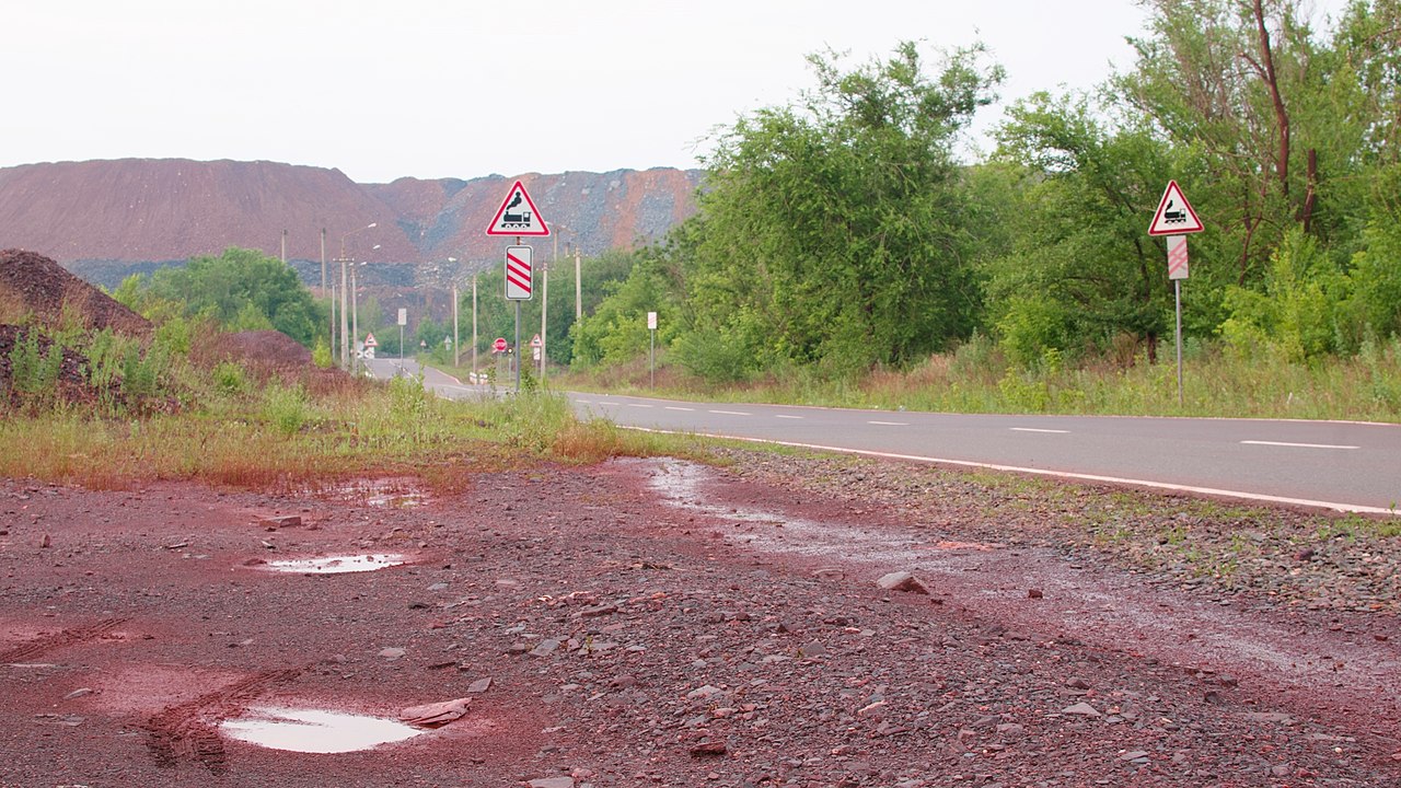
Kryvyi Rih(크리비 리)는 우크라이나의 대표적인 철광산지이다. 아래 1899년 사진을 보면 노천광산임을 알 수 있다. 키예프 남쪽 415km에 있는 도시이며, 남북으로 126km에 달하는 철광단지이며, 1700만톤의 철광을 생산한다 . (아래 자료 참조). 그래서 주위 환경에 공해를 주고 있으며, 길가의 도로는 적색으로 물들어 있다. (아래 그림 참조). 즉 철광산지로서는 철원으로서 가장 유력한 후보이다.
그런데 이 도시에서 좀 흥미로운 이야기가 3가지 있다.
1) 지역 전설에 의하면, 이 지역의 첫 마을은 Rih라 불리는 한쪽 눈의 코자크인에 의해 세워졌다는 것이다. (아래 자료 참조) 코자크 시기는 알 수 없으나, 궁예가 어릴 때부터 한쪽 눈인 것을 역사 자료는 말하고 있다. (자료 : 궁예, 나무위키, 필자의 네이버 블로그(lainfos), 카테고리, 후삼국, 참조)
"Etymology
Kryvyi Rih, which in Ukrainian literally means "Crooked Horn" or "Curved Cape", was the name originally given in the 18th century to the general area of the present city by Zaporozhian Cossacks. According to local legend, the first village in the area was founded by a "crooked" (Ukrainian slang for "one-eyed") Cossack named Rih ("Horn"), but the name likely derives from the shape of the landmass formed by the confluence of the river Saksahan with the Inhulets.[8] ........
Located 415 kilometres (260 mi) south of Kyiv, the city extends for 126 km from north to south,[125][126] paralleling the ore deposits. The city centre is on the east bank of the Inhulets River, near its confluences with the River Saksahan. Kryvyi Rih's geographic features were highly influential in its early development industrial city....
The city's environmental and construction safety is a growing problem due to abandoned mines and polluted ore-processing waste....
Processing and mining industry - the two largest sectors of Kryvyi Rih. Rest fraction is about 50%. City has over 53[149] plants, mines and factories. ArcelorMittal Kryvyi Rih, owned by ArcelorMittal since 2005 is the largest private company by revenue in Ukraine,[150] producing over 7 million tonnes of crude steel, and mined over 17 million tonnes of iron ore.
(source: Kryvyi Rih, Wikipedia, 인용출처: 필자의 티스토리 믈로그(lostcorea), 카테고리, Kievan Rus')

An ore quarry in 1899 (source: Wikipedia)
Red colored ground is commone because of Iron Oxides (source : Wikipedia)
2) Kryvyi Rih는 Saksahan river와 Inhulets river가 만나는 지점에 있다.
그런데 Saksahan 강의 이름은 튀르크 단어, Saksagan에서 왔다는 말이 있다 한다. Saksagan 튀르크어는 Magpie, 즉 까치를 말한다 한다. (아래 자료 참조) 유라시아 까치는 한국의 까치와 같이 흑색 백색의 색갈을 가지고 있다. (아래 그림 참조, Magpie에 대한 자료는 필자의 티스토리 블로그(lostcorea), 카테고리, Kievan Rus'글 참조) 까치는 한국의 국조이다. 즉 튀르크말이 있는 것도 이상한데, 한국의 역사에 익숙한 까치라는 말에서 강이름이 왔다는 것이다.
"The Saksahan (Ukrainian: Саксагань) is a river in Ukraine, in the southeastern part of the Dnieper Upland.[1] It is a left tributary of the Inhulets (Dnieper basin), joining the Inhulets in the city of Kryvyi Rih.
The name is derived, according to some sources, from the Turkic word Saksagan (magpie).
A village of the same name is found on the left (west) bank of the river.
The river lends its name to Saksahansky urban district of Kryvyi Rih city.[2]
The source of the river, in the modern territorial division, located by the village of Malooleksandrivka [uk], Kamianske Raion, situated at an altitude of 140 meters above sea level.
The river is 144 km long (according to some sources, it has a total length of 130 kilometers). The width of the river bed is an average of 5–15 meters, although in places it broadens to 20–40 (29 to 40) meters (watershed line - 250 km).[clarification needed]
(source : Saksahan, wikipedia, 인용출처: 필자의 티스토리 믈로그(lostcorea), 카테고리, Kievan Rus')
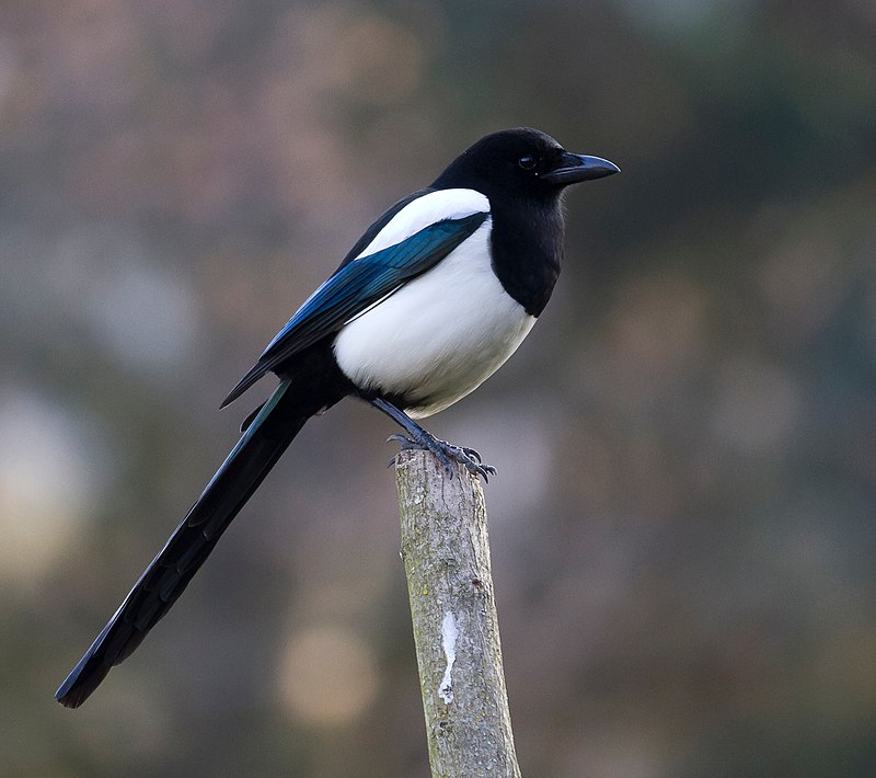
Pie (Pica pica) dans le jardin de Compans Caffarelli à Toulouse (프랑스 툴루즈 정원에 있는 까치, 자료: 위키피디아)
3) Kryvyi Rih는 드네프로강의 우측 지류인 Inhulets강(557km)에 접하였는데, 이 강은 Dnieper Upland에서 기원한다. 그런데 이강의 어원 역시 튀르크어 Iyen-kul이라 하며, 그 뜻은 wide lake(넓은 호수)라 한다. (아래 자료 참조). 그런데 이 말의 어원에 대해 설명이 없는 것이 아쉽다. 일부러 없는 것인가?
"The Inhulets (Ukrainian: Інгулець) is a river, a right tributary of the Dnieper, that flows through Ukraine. It has a length of 557 kilometres (346 mi) and a drainage basin of 14,460 square kilometres (5,580 sq mi).[2]
The Inhulets has its source in the Dnieper Upland in a ravine (balka) to the west of Topylo village,[2] in the Kropyvnytskyi Raion of Kirovohrad Oblast, about 30 kilometres (19 mi) from the Dnieper river, to which it initially flows parallel. The Inhulets turns south, where it flows through Kryvbas Iron Ore Basin, and the Kherson and Mykolaiv Oblasts, before finally flowing into the Dnieper about 30 kilometres (19 mi) east of the city of Kherson. The river flows through southern spurs of the Dnieper Uplands and then across the Black Sea Lowland.[2] The upper portion of the Inhulets basin is in the forest steppe zone, the lower part within the Pontic steppe.[2]
The river is dammed at the village of Iskrivka in Kirovohrad Oblast and about 30 kilometres (19 mi) further downstream at the city of Kryvyi Rih in Dnipropetrovsk Oblast to form reservoirs. The lower one, the Karachunivske Reservoir [uk], provides the water supply for Kryvyi Rih and for irrigation. On 14 September 2022 the Ukrainian government said a Russian missile attack had broken the dam, causing flooding.[3]
The course of the river near Kryvyi Rih has created many small islands, which have a rich vegetation. However, by 2017 the vegetation was impaired by the high level of contamination of the river, due to the nearby iron ore mining industry.[4]
Etymology : Turkic iyen-kul, "wide lake"[1]
(source : Inhulets, wikipedia, 인용출처: 필자의 티스토리 믈로그(lostcorea), 카테고리, Kievan Rus')
즉 Kryvyi Rih도시는 철광 산지 조건 뿐만 아니라, 주위의 강물들의 이름이 모두 튀르크어라는 것과, 이 도시의 설립자는 애꾸눈의 사나이라는 것, 그리고 까치라는 뜻의 강물이름이라는 것들이, 이 도시가 궁예의 도시 철원일 수 있다는 가능성을 높혀 주고 있는 것이다.
3. Nikopol 가능성
우크라이나의 중앙 철광 생산 단지에서 Nikopol도 언급된다. 그래서 철원의 가능성을 살펴 보자.
그런데 이 도시는 오랜 세기동안 드네프로강을 건너기 가장 좋은 지점이었다 한다. 그래서 그런지 아주 오래전 기원전 2천년대 구리-청동기 시대의 고분에서 유물과 토기가 나오고, 이후 스키타이문화의 유물이 나왔다 한다. 중기 신석기 시대의 유럽지도에서 Dnieper-Don culture가 흑해위 지역인데, 그 문화의 도시의 하나가 아니었나 한다. 그리고 기원전 2세기에서 기원후 2세기까지의 스키타이-사마르탄 시기의 무덤도 연구되고 있다 한다. (아래 자료 참조) 즉 스키타이 문화가 있는 도시이므로, 한국사의 가능성이 있는 곳이기는 하나, 특별히 궁예와 관련된 흔적은 보이지 않는다.
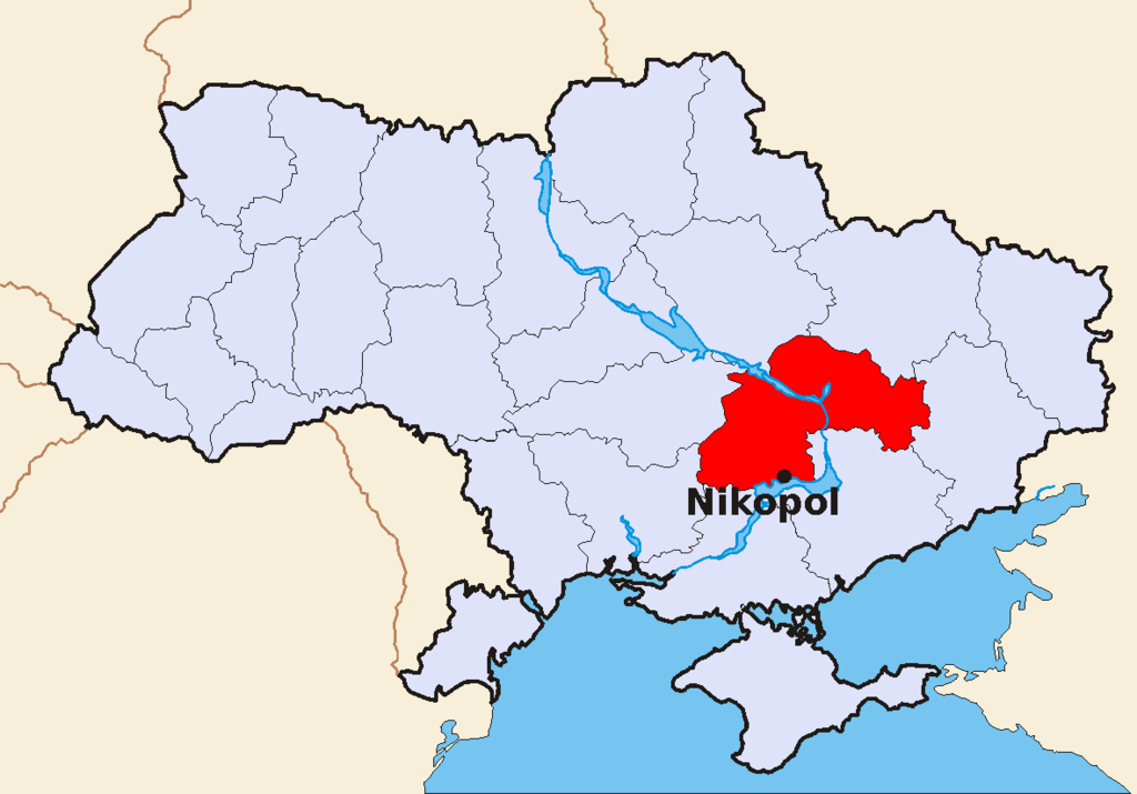
Location of Nikopol (source : Wikipedia)
"Encyclopedia Britannica description
The 1911 edition of Encyclopedia Britannica gave the following description of Nikopol: "It was formerly called Mykytyn Rih, and occupies an elongated peninsula between two arms of the Dnipro at a point where its banks are low and marshy, and has been for centuries one of the places where the middle Dnipro can most conveniently be crossed."
In 1900, its 21,282 inhabitants were Ukrainians, Jews and Mennonites, who carry on agriculture and shipbuilding. The old Sich, or fortified camp of the Zaporozhian Cossacks, brilliantly described in N. V. Gogol's novel Taras Bulba (1834), was situated a little higher up the river. A number of graves in the vicinity recall the battles which were fought for the possession of this important strategic point. One of the graves, close to the town, contained, along with other Scythian antiquities, a well-known precious vase representing the capture of wild horses. Even now Nikopol, which is situated on the highway from Dnipro to Kherson, is the point where the "salt-highway" of the Chumaks (Ukrainian salt-carriers) to the Crimea crossed the Dnipro. Nikopol is, further, one of the chief places on the lower Dnipro for the export of corn, linseed, hemp and wool.
History
Archaeological excavations
According to archaeological excavations, the city's area was populated as early as the Neolithic epoch in the 4th millennium BCE[3] as evidenced by remnants of a settlement discovered on banks of Mala Kamianka River.[3][4] In burial mounds of copper-bronze epoch in the 3rd-1st millenniums BCE were found stone and bronze tools, clay sharp-bottomed ornamental dishes.[3] Here also were researched burials of Scythian-Sarmatian period in the 2nd century BCE – the 2nd century CE.[3]
(source : Nikopol, wikipedia, 인용출처: 필자의 티스토리 믈로그(lostcorea), 카테고리, Kievan Rus')
4. Chernihiv의 가능성
철원은 또한 흑양이라는 별칭을 가졌다 한다. 흑양이란 부드러운 검은 흙이라는 뜻이다. 따라서 이러한 부드러운 흙의 조건을 감안한 철원을 고려할 때 Chernihiv가 그 가능성이 있다. 왜냐하면 Cherni는 슬라브어로 Black을 의미한다고 한다. (아래 자료 참조)
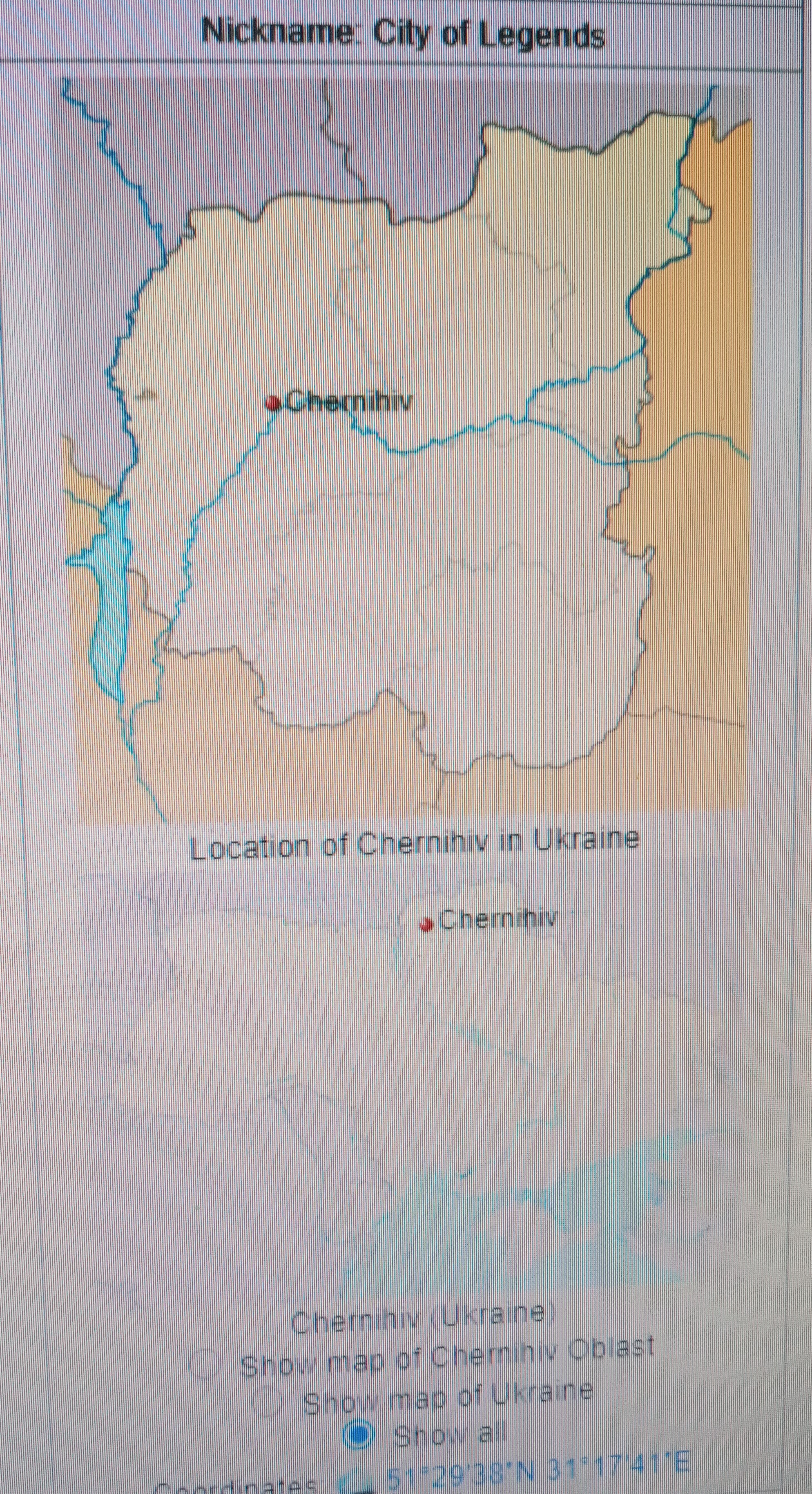
Location of Chernihiv (source : Wikipedia)
Chernihiv는 Desna강(150km)에 접해 있는데, 키예프의 북동쪽에 있다. 출토된 유물로 판단해서는 적어도 9세기에 거주지가 있었다 한다. 그리고 이곳에 Black Grave라는 동유럽에서 가장 오래 되고 가장 큰 왕족 무덤이 19세기에 발견되었다. (아래 자료 참조).
"Geography
Chernihiv stands on the Desna River 150 km (93 mi) to the north-north-east of Kyiv.
The area was served by Chernihiv Shestovytsia Airport prior to 2002, and during the Cold War it was the site of Chernihiv air base.
History
Etymology
The name "Chernihiv" is a compound name, which begins with the root 'Cherni/Cherno,' which means "black" in Slavic.[5] Scholars vary with interpretations of the second part of the name ("hiv"/gov", "говъ") though scholars such as Dr. Martin Dimnik, Professor of Medieval History at University of Toronto, connect Cerhnihov with the worship of "the black god" Chernibog.[6]
Early history
Chernihiv was first mentioned (as Черниговъ)[citation needed] in the Rus'–Byzantine Treaty (907), but the time of its establishment is unknown.[7] Artifacts from the Khazar Khaganate uncovered by archaeological excavations at a settlement there indicate that it seems to have existed at least as early as the 9th century. Towards the end of the 10th century, the city probably had its own rulers. It was there that the Black Grave, one of the largest and earliest royal mounds in Eastern Europe, was excavated in the 19th century."
(source : Chernihiv, wikipedia, 인용출처 : 필자의 티스토리 블로그(lostcorea), 카테고리, Kievan Rus')
Chernihiv 이 도시는 키예프 루스 남부에서 두번째로 부유한 도시이고 중요한 도시이다. 11세기초부터는 강력한 Chernihiv Grand Principality가 자리 잡았고, 여기 지도자는 키예프의 Grand Princes와 권력을 다투었고, 때로는 이들을 전복시키고 스스로 권력을 잡기도 했다. 이 Grand Principality는 키예프 루스에서 가장 컸으며, 심지어 먼 Murom, Ryazan, Tmutarakan까지 포함했다. 이 도시의 황금기에는 인구가 25,000명에 달했고, 1239년 몽고의 Batu khan에 포위된 후에는 상대적으로 긴 암흑기에 들어 갔다. (아래 자료 참조)
"The city was the second wealthiest and most important in the southern portion of the Kievan Rus'.[8] From the early 11th century on, it was the seat of the powerful Grand Principality of Chernigov (Ducatus Czernihoviensis), whose rulers at times vied for power with Kievan Grand Princes, and often overthrew them and took the primary seat in Kiev for themselves.
The grand principality was the largest in Kievan Rus and included not only the Severian towns but even such remote regions as Murom, Ryazan and Tmutarakan. The golden age of Chernigov, when the city population peaked at 25,000, lasted until 1239 when the city was sacked by the hordes of Batu Khan, and entered a long period of relative obscurity......"
(source : Chernihiv, wikipedia, 인용출처 : 필자의 티스토리 블로그(lostcorea), 카테고리, Kievan Rus')
Chernihiv 주위의 강은 Desna river(1130 km)와 Snov river(253 km)가 있다. 그러나 특별히 여울(raids)에 대한 언급은 없다.
"Rivers in Chernihiv
Desna River
The city of Chernihiv is crossed by Desna River which is a river in Russia and Ukraine, a major left tributary of the Dnieper river. "Desna" means "right hand" in the Old East Slavic language. Its length is 1,130 km (700 mi), and its drainage basin covers 88,900 km2 (34,300 sq mi).
In Ukraine, the river's width ranges from 60 to 250 m (200 to 820 ft), with its average depth being 3 m (9.8 ft). The mean annual discharge at its mouth is 360 m3/s (13,000 cu ft/s). The river freezes over from early December to early April, and is navigable from Novhorod-Siverskyi to its mouth, about 535 km (332 mi).
Snov River
Chernihiv also has the Snov river in Bryansk Oblast in Russia and Chernihiv Oblast in Ukraine, right tributary of the Desna River (Dnieper's basin). The length of the river is 253 km (157 mi). The area of its drainage basin is 8,700 km2 (3,400 sq mi). The Snov freezes in November – late January and stays icebound until March – early April. Part of the river forms the Russia–Ukraine border.
According to Ruthenian chronicles, in 1068 a battle took place at the Snov River between Duke of Chernihiv Sviatoslav Yaroslavich and Cumans led by Duke Sharukan."
(source : Chernihiv, wikipedia, 인용출처 : 필자의 티스토리 블로그(lostcorea), 카테고리, Kievan Rus')
Chernhiv에는 매우 큰 Black Grave가 있는 것으로 유명하다. Smolensk가까이 있는 Gnyozodov의 고분과도 비교되는데, 높이가 10미터가 넘고, 둘레가 170미터에 달한다. 1872-73년에 발굴되었는데, 두명의 Norse 전사(아마도 Chernihiv 왕자)의 화장된 유골이 나와고, 주위에 여러 부장품이 나왔다. 노예들, 제물이 된 동물들, 무기, 갑옷, 장식품 등이 발굴되었다. 노예들이 있다는 것은 순장문화를 말하지 않나 판단된다. 무덤시기는 10세기 늦은 시기로 추정되었다. (아래 자료 참조)
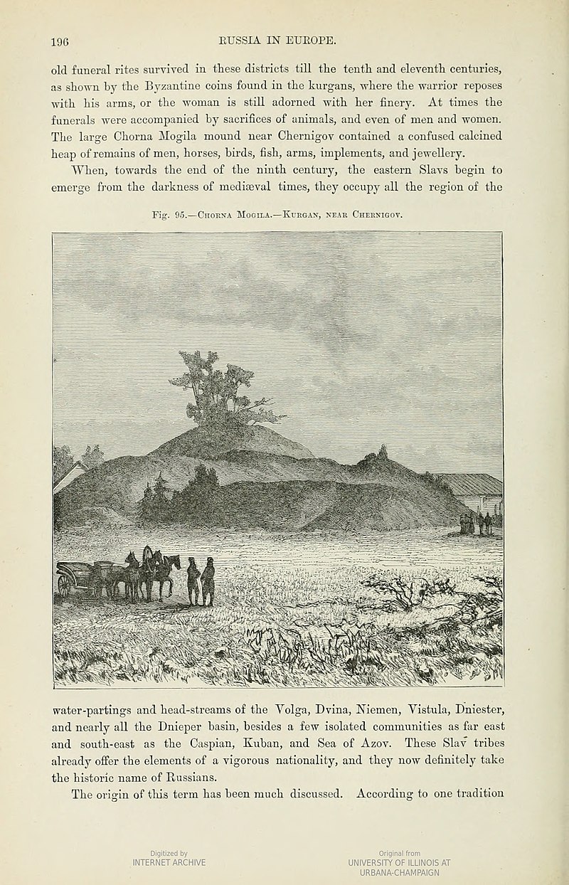
"The Black Grave (Ukrainian: Чорна могила, romanized: Chorna mohyla) is the largest burial mound (kurgan) in Chernihiv, Ukraine. It is part of the National Sanctuary of Ancient Chernihiv and is an Archaeological Monument of national importance.
Overview
Comparable to the barrows of Gnyozdovo near Smolensk, the Black Grave has a height of over 10 metres and a circumference of 170 metres.[1] During excavations undertaken in 1872–73, Dmitry Samokvasov uncovered two cremated bodies of Norse[citation needed] warriors (probably father and son), surrounded by slaves, sacrificial animals, arms, armour, and decorations. Samokvasov dated the burial to the late 10th century, when Vladimir I was the ruler of Kievan Rus. It is likely that the buried warriors were two princes (knyazes) of Chernihiv, although no local potentate is attested in the Slavonic chronicles before Vladimir's son, Mstislav of Chernihiv.
After the bodies were cremated, they were put upon a 7-metre-high mound, where a funeral feast took place. Arranged near the bodies were two helmets and knee-length chain mail (hauberks), probably extracted from the pyre, as well as a cauldron with ram bones, two sacerdotal knives, two golden Byzantine coins, an imported sabre, a miniature dark-red bronze idol of Thor, and two silver-bound aurochs horns decorated with floral motifs, fabulous animals, and figures of a man and a woman shooting at a bird. When the barrow was completed, a stele was placed at the top. All these items are now displayed at the State Historical Museum in Moscow."
(source: Black Grave, wikipedia, 인용출처 : 필자의 티스토리 블로그(lostcorea), 카테고리, Kievan Rus')
Chernihiv에는 유난히 Black이란 의미가 많이 언급된다. Black Grave, 검은 뜻이란 Cherni 등을 고려하면 그렇다. 그래서 혹시 흑양과 관련이 있나 싶어 라스푸티차에 대해 살펴 보았다.
라스푸티차는 벨라루스, 러시아, 우크라이나에 널리 퍼져 있는 습기가 많은 검은 토양을 말한다 한다. (아래 자료 참조) 그러나 이 지역에 있는 Chernozem지역에만 한한 것은 아니라는 것이다.
"These conditions in Belarus, Russia, and Ukraine are caused by high moisture storage capacity of black clay soils but not limited solely to the area of chernozem found in the region. Roads are subject to weight limitations and closures during the period in certain districts. The phenomenon was a notable hindrance in the early 20th century, since 40% of rural villages in the erstwhile Soviet Union were not served by paved roads.[6] The problem is less pronounced in elevated areas than in lowlands.
Roads that run through wetlands are particularly susceptible to damage. This phenomenon not only effects motorists but also pedestrians, mining, logging and agricultural companies creating deep ruts and furrows. During the time of rasputitsa, some farm products cannot be delivered to the city (i.e. to market) and must be destroyed.[8]
(source : Rasputitsa, wikipedia, 인용출처: 필자의 티스토리 블로그(lostcorea), 카테고리, 륵해 주위 rivers, cities)
Chernozem은 검은 색의 양분이 많은 토양을 말하는데, 농사에 매우 좋다. (아래 자료 참조) 그런데 우크라이나 동북부에 유난히 많다. (아래 지도 참조)
"Chernozem (from Russian: чернозём, tr. chernozyom, IPA: [tɕɪrnɐˈzʲɵm]; "black ground"),[1][2] also called Black soil or Regur soil or Black cotton soil, is a black-colored soil containing a high percentage of humus[3] (4% to 16%) and high percentages of phosphorus and ammonia compounds.[4] Chernozem is very fertile soil and can produce high agricultural yields with its high moisture storage capacity.[a] Chernozems are a Reference Soil Group of the World Reference Base for Soil Resources (WRB)"
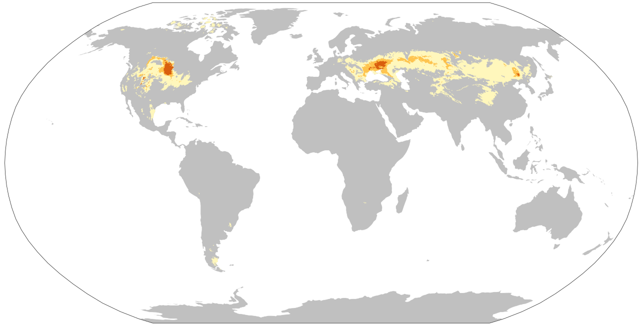
Chernozem Map (source : Wikipedia) (진노랑색 : 50%이상, 노랑색 : 25-50%, 백색 : 5-25%)
(source : Chernozem, Wikipedia, 인용출처 : 필자의 티스토리 블로그(lostcorea), 카테고리, Kievan Rus')
이상의 조건을 살펴 볼 때, Chernihiv 주위지역은 흑양의 이름을 가질 만한 지역으로 판단된다.
5. Ochakiv(드네프르강 하구)의 가능성
드네프르강 하구의 Ochakiv는 과거 고트족의 수도였다고 위키피디아 자료는 말한다. 필자는 아직 이에 대해 잘 이해를 하지 못하고 있으나, 고트족과 관련이 있다 하므로 살펴 보고자 한다.
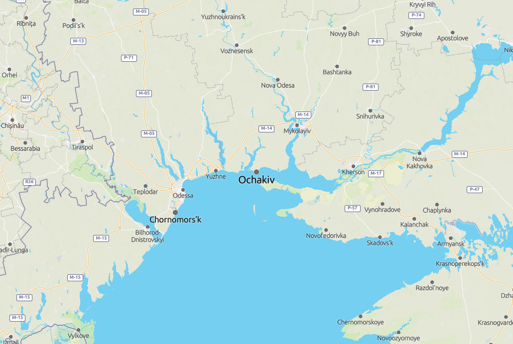
Location of Ochahiv (Capital of Goths)
"The strip of land, on which Ochakov is located today, was inhabited by Thracians and Scythians in ancient times. It was known as a part of Great (i. e. European) Scythia. In the 7th and 6th centuries BC, Greek colonists had founded a commercial colony town, named Alektor, near the Thracian coast. Archaeological excavations also show that near the area was the old Milesian (ancient Greek) colony of Pontic Olbia; it is supposed that the same Greek expeditions settled Alektor.[clarification needed]
옛날에 트라키언과 스키타인이 살았던 곳이라 한다. 기원전 7c-6c에 그리스 식민지로서 Alektor로 불려졌다. 기원전 1세기에는 로마의 식민지가 되었다. (백제를 말하는지 고구려를 말하는지 구분은 못하겠다). 이후 migrations 시기의 지나가는 지역으로 묘사된다. Bug강과 드네프르강의 해변에 조그만 거주지로 쇠퇴한 것으로 묘사된다.
In the 1st century BC, Alektor became a Roman colony and part of the Roman empire. The area was part of the space in which the Romanians' ethnogenesis took place, and was also more generally a place of passage for many migratory people and tribes. As a result of the migrations, the city fell and the inhabitants lived in small settlements built on the shores of the Bug and Dnieper Rivers.
중세에는 Vozia라 불리었으며, 몽골의 유럽 침입시에는 타타르의 지배가 되었다 한다. (아래 자료 참조) 이 타타르가 몽고의 침입에 저항하여 피난간 고려의 세력이 아닌가 하는 생각을 하게 된다. 지금의 크리미아 반도가 타타르의 지배하에 있었는데, 고려가 몽골의 침입에 맞서 강화도로 피난하여 저항한 역사를 고려할 때, 크리미아 반도가 강화도가 아닌지 모르겠다. 그렇다면 개경이 키예프가 될 수 있다. Smolensk나 Novgorod가 송악, 개경이라면, 그 북쪽 어디에 강화도가 있어야 하는데, 어딘가 너무 멀다. 차후 이후 시기의 역사에 대해 관심을 가지고 살펴볼 일이다.
During the Middle Ages the place was named Vozia by Romanians. The name is supposed to come from a plant known in Romanian as bozii or bozia (Sambucus ebulus), a medicinal herb frequently found there. The territory was a part of the Brodnici rule. It fell under Tatar domination in the time of the Mongol invasion of Europe........
(source : Ochakiv, Wikipedia, 인용출처 : 필자의 티스토리 블로그(lostcorea), 카테고리, 흑해주위 rivers, cities)
6. Phanagoria의 가능성
Phanagoria는 아조프해의 출구지점에 있는 도시인데, 아주 오래전 그리스 식민지로서 존재 했다. (아래 지도 참조)

Greek Colonies of the northern Black Sea (BC 450) (source : Wikipedia)
그런데 이 도시가 고구려 말기 지역으로 보이는 Old Great Bulgaria 시기 (632-665)에 수도였다고 아래 기록되었다. (아래 자료 및 필자의 글 참조).
https://lostcorea.tistory.com/1645
흑해 위 Old Great Bulgaria(632-668)는 고구려 말기 역사의 일부이다
흑해위 지역에는 AD 632년부터 불가리아가 나타난다. Old Grea Bulgaria, Kara Bulgar, Volga Bulgaria 등이 그것이다. 서양사에서는 Huns, 즉 훈족과 Bulgars, 즉 부여족을 아시아에서 온 부족으로 판단한다. 필자
lostcorea.tistory.com
고구려말 시기에 연개소문의 아들들이 내분으로 서로 싸울 때, 그들 일부의 일시적인 수도가 아니었나 한다. 그리고 704년에는 비잔틴제국의 Justinian II 황제가 일시적으로 이곳에 유폐되었다 한다. 당시에는 발해로 보이는 카자르의 지배였다 한다. 그리고 10세기에는 Rus'에 의해 침범되었다 한다. (아래 자료 참조) 즉 고구려, 발해, 고려의 통치지역이 아닌가 한다.
"The loyalty to Rome allowed Phanagoria to maintain a dominant position in the region until the 4th century, when it was sacked and destroyed by the invading Huns.
Middle Ages
By the 7th century, the town had recovered from a century of barbarian invasions. It served as the capital of Old Great Bulgaria between 632 and 665 under Kubrat.[citation needed]
Afterwards Phanagoria became (at least nominally) a Byzantine dependency. A Khazar tudun was nonetheless present in the town and de facto control probably rested in Khazar hands until the defeat of Georgius Tzul in 1016. In 704, the deposed Byzantine emperor Justinian II settled in Phanagoria (then governed by the Khazar tudun Balgatzin) with his wife Theodora, a sister of the Khazar Khagan Busir Glavan, before returning to Constantinople by way of Bulgaria.[citation needed]
In the 10th century, the town seems to have faced an invasion, supposedly by the Rus. After that, Phanagoria could not compete in significance with neighboring Tmutarakan."
(source : Phanagoria, Wikipedia, 인용출처 : 필자의 티스토리 블로그(lostcorea), 카테고리, 흑해 주위 rivers, cities )
이 Phanagoria는 전략적 지역으로 오랜 역사를 가지고 있지만, 철원의 조건인 철 생산지, 흑양의 부드러운 검은 흙 등 관련한 정보는 없다. 따라서 철원의 가능성은 적은 것으로 판단된다. 그러나 고구려, 발해, 고려의 통치지역으로서 주목되는 항구 도시로 추정된다.
7. Tmutarakan (=Hermonassa)의 가능성
Tmutarakan은 Phanagoria 바로 아래 도시로 그리스 식민지였을 때는 Hermonassa로 불리었다. (아래 지도 참조) Phanagoria가 쇠퇴한 후 뒤를 이은 무역의 거점이었다.
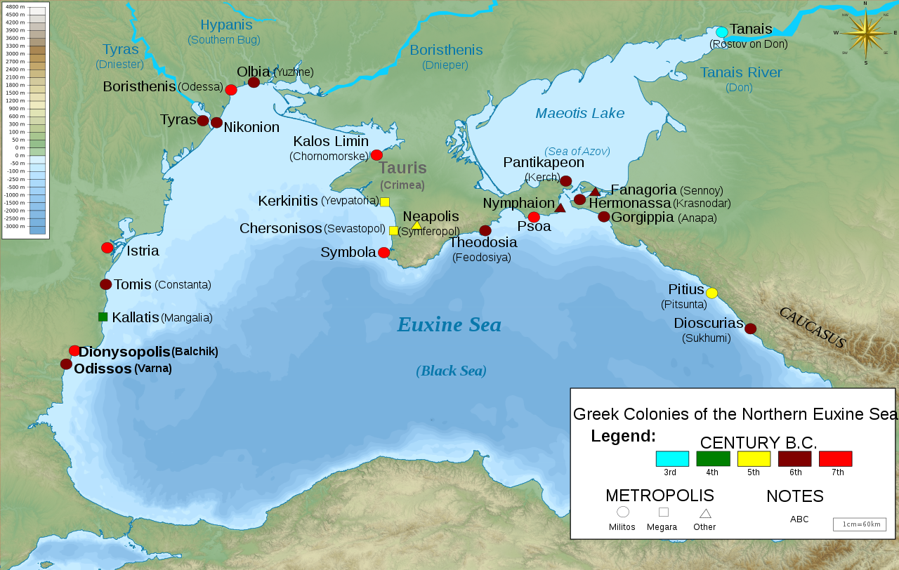
Greek colonies of Northern Black Sea (source : Wikipedia)
이 도시는 키예르 루스의 principality였으며, 흑해에서 아조프해로 지나가는 Cimmerian Bosphorus라 불리는 곳을 관리하는 무역도시였다. (아래 자료 참조) 이곳에는 카자르시대의 요새가 7세기에 지어 졌으며, 도시 이름도 그 성이름을 본 딴 것이라 한다.
"Tmutarakan[1] (Russian: Тмутарака́нь, IPA: [tmʊtərɐˈkanʲ], Adyghe: Тамтаркъей, romanized: Tamtarqey; Ukrainian: Тмуторокань, romanized: Tmutorokan) was a medieval Kievan Rus' principality and trading town that controlled the Cimmerian Bosporus, the passage from the Black Sea to the Sea of Azov, between the late 10th and 11th centuries. Its site was the ancient Greek colony of Hermonassa (Ancient Greek: Ἑρμώνασσα) founded in the mid 6th century BCE, by Mytilene (Lesbos), situated on the Taman peninsula, in the present-day Krasnodar Krai of Russia, roughly opposite Kerch.[2] The Khazar fortress of Tamantarkhan (from which the Byzantine name for the city, Tamatarcha, is derived) was built on the site in the 7th century, and became known as Tmutarakan when it came under Kievan Rus control....
4-5세기 훈족의 역사가 있는 것이며, 6세기에는 불가르(Bulgars)족(고구려)에 의해 취해졌고, 이후 7세기에 카자르(발해)에 의해 지배된다.
After a long period as a Roman client state, the Bosporan kingdom succumbed to the Huns, who defeated the nearby Alans in 375/376. With the collapse of the Hunnic Empire in the late 5th century, the area passed within the Roman sphere once again but was taken by the Bulgars in the 6th century. Following the fall of the city to the Khazars in the late 7th century, it was rebuilt as a fortress town and renamed Tamatarkha. Arabic sources refer to it as Samkarsh al-Yahud (i.e., "Samkarsh of the Jews") in reference to the fact that the bulk of the trading there was handled by Jews.[7] Other variants of the city's name are "Samkersh" and "Samkush".[8]
이곳은 상업도시로서, 비잔틴제국과 북코카서스지역과 무역하는 북유럽 무역을 통제하는 곳이기도 했다. 이곳에는 그리스인, 아르메니아인, 루스인, 유대인, 오세티언, Lezgins, 조지아인, Circassians 등 다양한 인종이 거주했다. 카자르가 망한 후에 키예프루스가 지배한 후에도 카자르인들은 계속 머물러 살았다. (아래 자료 참조)
Fortified with a strong brick wall and boasting a fine h인arbor, Tamatarkha was a large city of merchants. It controlled much of the Northern European trade with the Byzantine Empire and Northern Caucasus. There were also trade routes leading south-east to Armenia and the Muslim domains, as well as others connecting with the Silk Road to the east. The inhabitants included Greeks, Armenians, Rus', Jews, Ossetians, Lezgins, Georgians, and Circassians. After the destruction of the Khazar empire by Sviatoslav I of Kiev in the mid-10th century, Khazars continued to inhabit the region. The Mandgelis Document, a Hebrew letter dated AM 4746 (985–986) refers to "our lord David, the Khazar prince" who lived in Taman and who was visited by envoys from Kievan Rus to ask about religious matters.
Although the exact date and circumstances of Tmutarakan's takeover by Kievan Rus are uncertain, the Hypatian Codex mentions Tmutarakan as one of the towns that Vladimir the Great gave to his sons, which implies that Rus control over the city was established in the late 10th century and certainly before Vladimir's death in 1015.[9] Bronze and silver imitations of Byzantine coinage were struck by the new rulers during this period.[10][11]......
이 지역에는 Greek Fire 무기의 핵심원료인 naphtha가 매장되어 있는 곳이라서, 비잔틴제국의 관심이 있었다. (아래 자료 참조)
Byzantine interest in the city was maintained through this succession of client rulers, and thereafter by more direct rule for a while, for an important reason. There were naphtha deposits in the area and this was a vital ingredient of their main tactical weapon, Greek Fire.[17] Up until the end of the 12th century the imperial authorities were forbidding their Genoese trading partners access to the city known to them as Matracha.[18]
(source : Tmutarakan, Wikipedia, 인용출처 : 필자의 티스토리 블로그(lostcorea), 카테고리, 흑해 주위 river, cities)
이 도시 역시 Phanagoria와 마찬가지로 전략적 무역항구도시로서 상업적 활동이 활발한 도시였지만, 수도로서 철원과는 거리가 있는 도시였다. 오히려 그 상업적 활동과 여러 민족의 사람들이 거주하는 모습을 보면, 고려의 무역도시 벽란도가 생각나기도 한다.
VI. 한탄강의 위치 추정
한탄강의 위치 추정에 있어서는 상기 철원의 위치 추정을 참고하여, 드네프르강과 Kuban river에 한하고자 한다. Novgorod, Smolensk를 잇는 Volkhov river도 여울이 있다고 하나, 이들 지역은 송악에 보다 가능성이 많으므로 생략하고자 한다. Volkhov강에 대해서는 송악의 위치를 추정하는 글에서 별도로 언급하고자 한다.
1. Dnieper river의 가능성
드네프르강에 대해서는 2019년 4월 혹시 한탄강이 아닌가 하는 글을 썼다. (아래 글 참조). 당시 고트족의 수도가 이 부근이라는 기록과 드네프르강이 여울이 많다는 기록을 참고한 것이었다.
https://blog.naver.com/lainfos/221516496668
드네프로강은 태봉(후고구려) 궁예의 한탄강인가?
드네프로강은 태봉 (후고구려) 궁예의 한탄강인가? 한탄강은 후고구려를 세운 궁예가 수도 철원을 한탄강 ...
blog.naver.com
그러나 이제는 보다 심도 있는 분석을 해야 할 것이다. 한탄강의 여울 조건 뿐만아니라 부근의 철원, 흑양의 위치도 감안해야 하는 것이다. 철원은 철의 생산지라는 의미를 내포하고 있고, 흑양은 부드러운 검은 흙이라는 뜻이다. 따라서 이러한 의미를 가진 도시를 찾는 일도 같이 분석되어야 할 것이다. 본 글의 앞부분에서 철원, 흑양의 가능성이 높은 지역(Kryvyi Rih, Cherniv)은 모두 드네프르강 주위에 있었다. 그러므로 드네프르강이 매우 강력한 한탄강의 후보가 된다.
Dnieper river (source : Wikipedia)
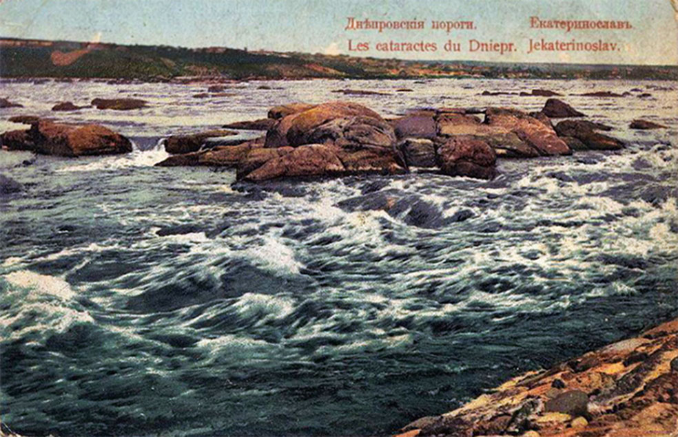
Rapids (여울) in Dnieper river in 1915 (source : Wikipedia)
드네프르강의 여울은 역사적으로 유명하다. 그래서 이에 대한 기록을 아래 잠시 살펴보자.
"The Dnieper Rapids (Ukrainian: Дніпрові пороги, Dniprovi porohy) are the historical rapids on the Dnieper river composed of outcrops of granites, gneisses and other types of bedrock of the Ukrainian Shield. The rapids began below the present-day city of Dnipro where the river turns to the south, and dropped 50 meters in 66 kilometers, ending before the present-day city of Zaporizhzhia (whose name literally means beyond the rapids).
There were nine major rapids along this path (although some sources give a smaller number) which almost totally obstructed the river for navigation. Also, there were about 30-40 smaller rapids and 60 islands and islets.
항해를 방해할 정도의 큰 여울은 약 9개 정도 된다. 조그만 여울은 30-40개 정도 그리고 섬은 60개정도 된다.
After the Dnieper Hydroelectric Station was built in 1932, they were inundated by the Dnieper Reservoir.
Historical mentions
The Dnieper Rapids were part of the trade route from the Varangians to the Greeks first mentioned in the Primary Chronicle. The route was probably established in the late eighth and early ninth centuries and gained significant importance from the tenth until the first third of the eleventh century. On the Dnieper the Varangians had to portage their ships round seven rapids, where they had to be on guard for Pecheneg nomads.
드네프르강 여울은 바랑기언이 그리스까지 가는 무역루트의 일부이다. 이길은 8세기후나 초기 9세기에 확립되고, 10세기에서 11세기 후반까지 매우 중요했다. 드네프르강에서 바랑기언들은 7개의 여울주위에서 그들의 배를 옮겨야 했고, Pechenegs유목민들의 습격에 대한 감시를 서야 했다. (위 자료 참조). 이러한 여울의 존재는 콘스탄틴 VII황제의 기록에서 그리고 Igor의 원정 이야기(12세기의 Igor)에서 언급된다. (아래 자료 참조)
The existence of the rapids was mentioned in Emperor Constantine VII's work De Administrando Imperio[1] and in The Tale of Igor's Campaign."
(source : Dnieper rapids, Wikipedia, 인용출처 : 필자의 티스토리 블로그(lostcorea), 카테고리, Kievan Rus)
즉 여울에 대한 이야기는 드네프르강이 제일 유명하다. 따라서 한탄강의 가능성이 제일 높다.
2. Kuban river의 가능성
앞서 위에서 살펴 본 Phanagoria 등의 우측에 Kuban river가 있는데, 이 강 또한 여울이 있다 해서 자료를 살펴 본다. (아래 Kuban river 지도 참조)
Map of Kuban river (source : Wikipedia)
Kuban river는 코카서스산맥의 가장 높은 산 Elbrus에 수원이 있다. Ullukam 수원에서 델타까지 906km의 강 길이이다. 대부분 깊고 좁은 계곡을 지나며, 강의 높이도 급격히 변화한다. 따라서 바람이 불고 많은 여울이 있다. (아래 자료 참조).
"The river originates on the slopes of Mount Elbrus and forms at the merger of its two tributaries, Ullukam and Uchkulam; from the source of Ullukam to the delta, it has a length of 906 kilometres (563 mi). Between the source and Nevinnomyssk the river flows mostly in the deep and narrow gorge, has many thresholds and rapidly changes its elevation.......There it is winding and has many shoals and rapids.......
(자료 : Kuban river, Wikipedia, 인용출처 : 필자의 티스토리 블로그(lostcorea), 카테고리, 흑해주위 river, cities)
그러나 Kuban river는 무역 루트도 아니고 과거 기록도 별로 없으며, 무엇보다 철원의 후보가 될 만한 지역이 주위에 없다는 것이다. 따라서 여울이 있지만 한탄강은 아닌 것으로 보인다. Oleg(궁예)가 Igor(왕건)에게 밀려나 도주하는 방향이 이쪽이 될 수도 있다.
키예프 루스 역사에서 Oleg에서 Igor로 권력이 이양되는 시기에 카스피해쪽에 약탈을 한 기록이 있는데, Igor가 한 일인지 확실치 않다고 한다. (아래 자료 참조) 혹시 Oleg(궁예)가 피신하며 저지른 일이 아닌가 생각된다. Phanagoria가 10세기에 Rus'의 침입을 받는데, Oleg 시기 이 곳까지 진출한 것으로 판단된다.
"In 913 and 944, the Rus' plundered the Arabs in the Caspian Sea during the Caspian expeditions of the Rus', but it remains unclear whether Igor had anything to do with these campaigns."
(source : Igor, Wikipedia, 인용출처 : 필자의 티스토리 블로그(lostcorea), 카테고리, Kievan Rus)
VII. 맺는 말
이상으로 살펴 본 바를 정리하면 다음과 같다.
1) Oleg와 Igor의 역사를 고려하면, Kiev가 철원으로 판단할 수 있다.
2) 철원이 철의 산지라는 것을 고려하면 Kryvyi Rih가 철원이 될 수 있다. 그리고 이 도시는 애꾸눈의 코자크인이 건설했다는 지역 전설이 존재한다고 한다. 또한 이 도시를 둘러싼 두 강의 이름이 모두 튀르크말에서 왔다 한다. 그중 Saksahan river는 까치라는 Magpie 뜻의 튀르크 말에서 연유한다는 것이 특이하다. 즉 이 지역에 튀르크계 역사가 있었다는 의미이다. 이런 연유로 필자는 이 곳이 철원일 확율이 매우 높다고 판단한다.
3) Chernihiv가 흑양의 검정색 의미를 가지고 있고, Black Grave가 있다는 점에서 가능한 후보이다. 그런데 Chernozem, 즉 흑양에 해당하는 지역은 상기 지도에서 본 바와 같이 우크라이나의 상당한 지역을 포함한다. 따라서 꼭 Chernihiv가 아니라도 흑양일 수 있다는 판단이다.
이상을 고려할 때, Kryvyi Rih가 철산지와 흑양지역일 가능성이 높기 때문에 철원일 가능성이 가장 높다고 본다. Kiev는 후세에 들어 더 발달한 도시일 가능성도 있다.
그리고 이러한 철원의 위치를 고려하면, 여울에 관한 많은 기록을 고려하면, 한탄강은 드네프르강(Dnieper river)이라고 판단된다.
'한국사 > 고려' 카테고리의 다른 글
| 고려의 강동6주는 독일의 Elbe강 동쪽에 있었다 (1) | 2022.09.09 |
|---|