Canton of St. GallenKanton Sankt Gallen(German)Canton of St GallCapitalSubdivisionsGovernment • Executive • LegislativeArea[1] • TotalPopulation(December 2020)[2] • Total • DensityISO 3166 codeHighest pointLowest pointJoinedLanguagesWebsite
Located innortheastern Switzerland, the canton has an area of 2,026 km2(782 sq mi) (5% of Switzerland) and a resident population close to half a million as of 2015 (6% of Switzerland). It was formed in 1803 as a conflation of the city ofSt. Gallen, the territories of theAbbey of St. Galland various former subject territories of theOld Swiss Confederacy.
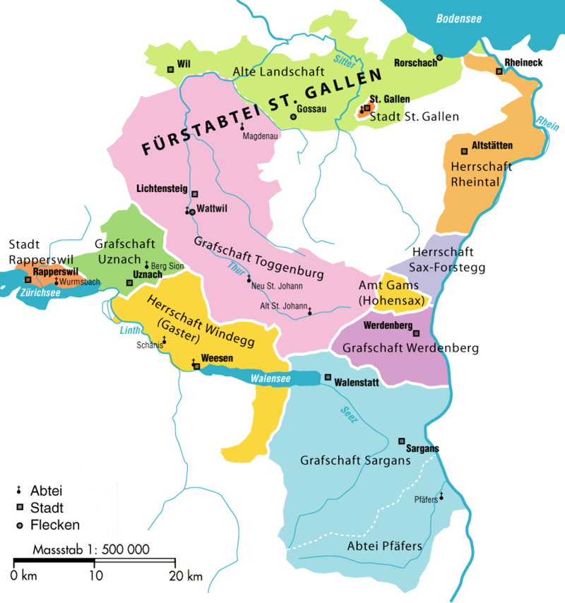
The canton of St. Gallen is an artificial construct of various historical territories, defined byNapoleon Bonapartein theAct of Mediationin 1803. About half of the canton's area corresponds to the acquisitions of theabbey of St. Gallenover centuries.
The city of St. Gallen became independent of the abbey in 1405. At the same time, the abbey lost control ofAppenzell. Conversely, theToggenburgwas acquired by the Abbey in 1468.
The territories atLake Zürich,WalenseeandRheintalremained independent until 1798. In the Helvetic Republic, the northern parts of the modern canton together with Appenzell became thecanton of Säntis, while its southern parts together withGlarusbecame thecanton of Linth.
However, the two new Cantons had immediate financial problems and were forced to institute a number of unpopular taxes and laws. The Abbey was secularized on 17 September 1798 and the Prince-Abbot Pankraz Vorster fled to Vienna. The unpopular laws and the closing of the Abbey caused unrest throughout the area. When theWar of the Second Coalitionbroke out in 1799, an Austrian army marched into eastern Switzerland and returned the Prince-Abbot to his throne at the Abbey. However, his victory was short-lived. The Austrian and Russian armies were defeated outside Zürich and the French Army returned to St. Gallen driving the Prince-Abbot out.
In 1803, as part of theAct of Mediation, the area joined the Swiss Confederation as the Canton of St. Gallen.[3]
The cantonal constitution of 1803 was revised in 1814. Because of the confessional heterogeneity of the canton's population, the 1814 constitution did unusually organise matters of religion, marriage and education not on a cantonal level but introduced a twofold division (confessional dualism), with separate Protestant and a Catholic assemblies subordinate to the legislative cantonal assembly (Grosser Rat).
The constitution was revised again in 1831, introducing elements of direct democracy. The constitution of 1831 divided the canton into 15 districts (Bezirke), reduced to 14 in 1918 (fusion of Tablat district with St. Gallen district).
Due to continuing confessional squabbles over the organisation of schools, the canton eventually placed education under its authority in 1861.
The constitution was yet again revised in 1890, with a stronger emphasis on direct democracy.
The 1890 constitution remained in effect, with numerous later changes, until 2001, the date of the latest revision of the cantonal constitution.
In the 2001 constitution, the division into districts was replaced by a division into eight constituencies (Wahlkreise), effective on 1 January 2003.
The main rivers of the canton are theRhine,Thur,LinthandSeez. The topography changes from the plains, near river Rhine and Lake Constance, towards the mountainous areas of theAlpsin the south (Appenzell AlpsandGlarus Alps). About one third (619.7 square kilometers (239.3 sq mi)) of the canton is wooded, while nearly half is 9,790.6 km2(3,780.2 sq mi) is used for farming. 278.6 km2(107.6 sq mi) of the farm land is alpine pastures. Of the rest of the canton, 259.1 km2(100.0 sq mi) is considered unproductive while 176 km2(68 sq mi) is filled with housing or roads.[4]
The altitude above the sea-level varies from 398 m (1,306 ft) (the lake of Constance) to 3,251 m (10,666 ft) (the Ringelspitz). The canton includes portions of the lake of Constance (54 km2(21 sq mi)), of the Walensee (rather over 18 km2(6.9 sq mi)), and of the lake of Zürich (10 km2(3.9 sq mi)), and several small lakes wholly within its limits.[5]