Saarlouis(German:[ˌzaːɐ̯luˈiː]; French:Sarrelouis,[saʁlwi]; formerlySarre-LibreandSaarlautern) is a town inSaarland, Germany, capital of the district ofSaarlouis. In 2017, the town had a population of 34,758. Saarlouis, as the name implies, is located on the riverSaar. It was built as a fortress in 1680 and was named afterLouis XIV of France.
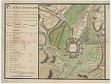
With theTreaties of Peace of Nijmegenin 1678/79,Lorrainefell to France. In 1680,Louis XIV of Francegave orders to build a fortification (to defend the new French eastern frontier) on the banks of the river Saar which was calledSarre-Louis. Notable Frenchmilitary engineer,Sébastien Le Prestre de Vauban, constructed the town, which would serve as the capital of theProvince de la Sarre. The plans were made by Thomas de Choisy, the town's first Gouvenour. In 1683, Louis XIV visited the fortress and granted arms. The coat of arms shows the rising sun and threeFleur-de-lis. The heraldic motto isDissipat Atque Fovet: He (the Sun) dispels (the clouds) and heats (the earth).
In 1697, theTreaty of Ryswickmade most parts of Lorraine independent again, but Saarlouis and the surrounding areas remained a Frenchexclave. During theFrench Revolution, the town was renamed Sarre-Libre, but it returned to its original name in 1810. With theTreaty of Parisin 1815, Saarlouis (and the whole region later known as theSaargebiet) becamePrussian.
MarshalMichel Ney, who was born in Saarlouis, was arrested and tried fortreasonafter the failure ofNapoleon I'sWaterloo Campaign. Ney's attorney tried to use the Prussian annexation to save his client's life, arguing that Ney was no longer a French citizen and therefore exempt from the court's jurisdiction. Ney refused to cooperate, declaring himself to be French, and so was convicted and later executed.
AfterWorld War I, French troops occupied Saarlouis. The Saargebiet became a protectorate of theLeague of Nationsfor 15 years. In 1933, a considerable number of anti-NaziGermansfled to the Saar, as it was the only part of Germany left outside theThird Reich's control. As a result, anti-Nazi groups campaigned heavily for the Saarland to remain under control ofLeague of Nationsas long asAdolf Hitlerruled Germany. However, long-held sentiments against France remained entrenched, and very few sympathized openly with France. When the 15-year-term was over, aplebiscitewas held in the territory on 13 January 1935: 90.3% of those voting wished to rejoin Germany.
From 1936 till 1945, Saarlouis was named as Saarlautern (-lauternbeing a common ending of town and village names in Germany) in an attempt by the Nazis to Germanise the town name.
AfterWorld War II, the region (then called theSaarland), was again occupied by France. In a plebiscite in 1955, most of the people in the Saarland opted for the reunification with theFederal Republic of Germany, and on 1 January 1957, it became the 10th federal state of West Germany.
In 1980, Saarlouis celebrated its 300th anniversary.
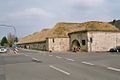
Even today, thefortressdominates the town's hexagonal floor plan. Beside the buildings made byVauban, there are also some constructions left from the 19th century when thePrussiansgot control over the town. After 1887, some parts of the fortress wereslighted, but many buildings and places, e.g. thecasemates, somebarracksand theGreat Marketwith the Commander's Office and theVauban island, a formerravelinwith a memorial forMichel Neycan still be seen today.
Saarlouis was famous for its nearby steel and iron ore production and its nearby mining facilities. Today, theFord Motor Company'sSaarlouis Body & Assemblyis the town's largest employer, producing theFord Focus. The plant in the Roederberg suburb opened in 1970, but in 2022 is threatened with closure when the Ford Focus production cycle runs out in 2025.[3]
Inland Port Saarlouis/Roden
The industrial port in Saarlouis-Roden is Germany's 13th largestinland port.[4]Saarlouis is also a manufacturer of chocolate.[5]