Bex
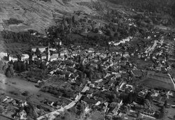
Bex (French: [be]; German: Beis; Arpitan: Bés) is a municipality in the canton of Vaud, Switzerland, located in the district of Aigle. It is a few kilometers south of its sister town municipality of Aigle.
History
Bex is first mentioned in 574 as in Baccis.[3]
Salt mine

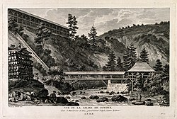
Bex is the site of a famous salt mine.
The salt deposits in Bex were the first ones discovered in Switzerland. In the 15th century, a salt source is mentioned in the area, but it was not until 1554 that a large deposit was discovered in Panex. Production of the salt began shortly thereafter. In 1582 a salt works was built in Roche. Initially the salt works were run by Bernese patricians, and then foreign nobles. In 1685 the salt mines came under the direct control of the Bernese state. At the beginning of the 18th century, it was entrusted to a general director, the most famous one being Albrecht von Haller.[4]
To provide wood for the salt works in Roche, in 1695 a forest was planted in the Joux Verte gorge. Starting in the 16th century, natural evaporation was replaced by boiling to speed up salt production. The first tunnels were dug in 1684 to find new salt sources. Salt deposits were discovered in Le Bévieux and Les Devens (both part of the municipality of Bex) and Aigle. The mine at Le Bévieux was still in operation at the beginning of the 21st century.[4]
Geography

Bex has an area, as of 2009, of 96.56 square kilometers (37.28 sq mi). Of this area, 25.85 km2 (9.98 sq mi) or 26.8% is used for agricultural purposes, while 32.42 km2 (12.52 sq mi) or 33.6% is forested. Of the rest of the land, 4.48 km2 (1.73 sq mi) or 4.6% is settled (buildings or roads), 0.84 km2 (0.32 sq mi) or 0.9% is either rivers or lakes and 33.01 km2 (12.75 sq mi) or 34.2% is unproductive land.[5]
Of the built up area, housing and buildings made up 2.0% and transportation infrastructure made up 1.6%. Out of the forested land, 28.1% of the total land area is heavily forested and 2.6% is covered with orchards or small clusters of trees. Of the agricultural land, 4.3% is used for growing crops and 5.8% is pastures, while 2.0% is used for orchards or vine crops and 14.7% is used for alpine pastures. All the water in the municipality is flowing water. Of the unproductive areas, 9.4% is unproductive vegetation, 23.1% is too rocky for vegetation and 1.7% of the land is covered by glaciers.[5]
Bex sits on the east side of the Rhone River in a wide valley surrounded on the east by the Pays d'en Haut and the Bernese Alps and on the west by the Chablais Alps. The municipality is located in the Aigle district, along the Avançon river. It stretches from the banks of the Rhone (395 m (1,296 ft)) to the Alps. It includes most of the highest mountains of the canton: Les Diablerets peak (3,210 m (10,530 ft)), Grand Muveran, Dent Favre and Dent de Morcles. The municipality consists of the town of Bex and the hamlets of Le Châtel, Les Dévens, Le Chêne, Fenalet, Les Posses, Le Bévieux, Frenières and Les Plans-sur-Bex.
Famous ski resorts are nearby, notably Villars-sur-Ollon and Gryon, a few kilometres above the town. Bex is also connected to Les Diablerets by the mountain pass Col de la Croix.
'역사 자료 > 스위스' 카테고리의 다른 글
| <펌>Thur (Rhine) (0) | 2022.09.04 |
|---|---|
| <펌> Alpine Rhine (0) | 2022.09.02 |
| <펌>Bad Ragaz (0) | 2022.09.02 |
| <펌> Canton of St. Gallen (0) | 2022.09.02 |
| <펌>Handegg Falls (Switzerland) - Britannica (0) | 2022.09.02 |